
The Basics of Drone Surveying and Mapping: Everything You Need to Know
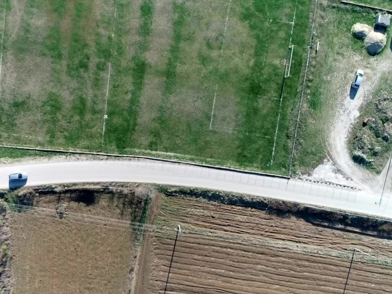
Drone surveying and mapping is a rapidly growing field that is revolutionizing the way land surveys are conducted. Drones, also known as unmanned aerial vehicles (UAV), are equipped with high-resolution cameras and sensors that can capture detailed images and data from a bird’s-eye view. This technology has numerous advantages over traditional land surveying methods, including increased efficiency, accuracy, and safety.
Capturing high-resolution images and data with drones is faster than conducting a ground survey. Drones enable surveying of difficult or dangerous terrain, like steep slopes and dense forests, which are hard for humans to navigate.
Another advantage of drone surveying is its versatility. Drones can be used for a wide range of applications, from drone mapping and surveying to monitoring construction sites and inspecting infrastructure. They can capture a variety of data deliverables, including orthomosaic maps, digital surface models, and point clouds, which can be used to create highly detailed 3D models of the terrain.
With their advanced sensors and cameras, drones can also collect data on vegetation health, water quality, and other environmental factors.
We are mostly talking about mapping, the biggest advantages are the geometric accuracy of the data, the small localization error, as well as the resolution.
Compared to satellite images, the speed and efficiency, as well as the area covered in a short time interval, is low. Drones depend a lot on the capacity of the batteries they have, as well as the limitation related to the altitude at which they can fly, compared to satellite images, which take the images, even at very good resolutions, on much larger surfaces, in less time.
Key Takeaways – What Is Drone Surveying and Mapping?
- Drone surveying and mapping is a fast and efficient way to conduct land surveys with increased accuracy and safety.
- Drones can capture high-resolution images and data in a fraction of the time it would take to conduct a ground survey, and can access hard-to-reach areas.
- Drones are versatile and can be used for a wide range of applications, including mapping, surveying, monitoring, and inspection. They can capture a variety of data deliverables, including 3D models and environmental data.
- Various techniques can be applied like carbon REDD projects for calculating the carbon amount sequestrated in forests based on forest heights.
Applications of mapping and surveying using Drones
There is a wide range of applications across various industries for surveying and mapping using drones. Their ability to capture high-resolution images and data make them perfect tool for land surveyors. In this section, we will discuss some of the most common applications of drone mapping and surveying which can be used for planning, design, monitoring, and conservation efforts.
Construction and Civil Engineering
Construction and civil engineering companies use drone surveying and mapping to gather data for site planning, design, and construction. Drones can capture detailed images and data of construction sites, which can be used for creating 3D models, BIM (Building Information Modeling), and accurate topographic maps. This data can be used to plan and design construction projects, monitor progress, and ensure quality control. Drones in construction provide faster data capture and improved safety over traditional land surveying methods.
Agriculture and Crop Monitoring
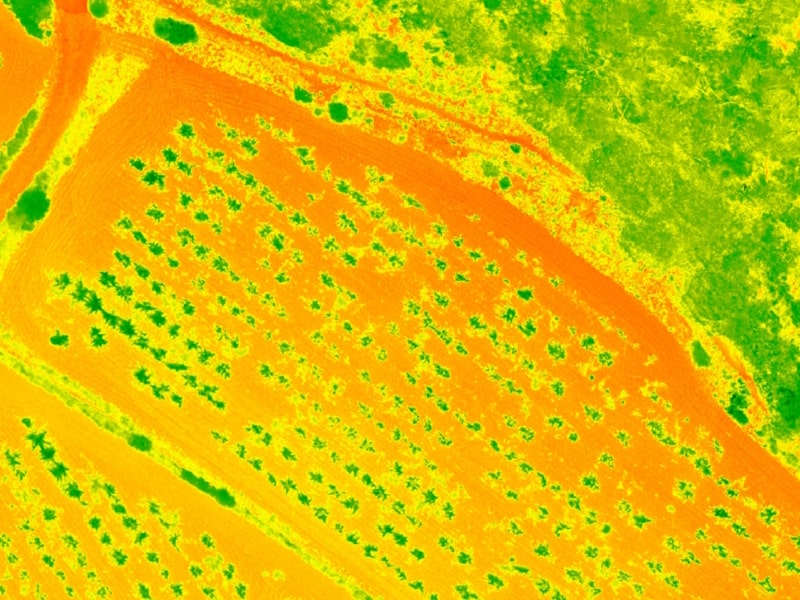
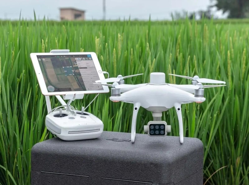
Drones are increasingly being used in agriculture for crop monitoring and management. Drones equipped with multispectral cameras can capture images of crops, which can be used to identify areas of stress, disease, and nutrient deficiencies. This data can be used to optimize crop management practices, reduce waste, and increase crop yields.
Read more: Crop Spraying Drone Solutions for Smart Farming
Environmental Monitoring and Conservation
Drones are also being used for environmental monitoring and conservation. They can be used to capture images of forests, wetlands, and other natural areas, which can be used to monitor changes in vegetation, water levels, and wildlife populations. Drones in forestry provide detailed aerial data that can be used to make informed decisions about conservation efforts and protect natural resources
Archaeology and Cultural Heritage Preservation
Drones are also being used for archaeology and cultural heritage preservation. They can capture high-resolution images of archaeological sites, which can be used to create detailed 3D models and maps. This data can be used to study and preserve cultural heritage sites.
What Is the Level of Accuracy in Drone Data Land Surveys?
The level of accuracy in drone land surveys is dependent on several factors, including the drone’s specifications, the quality of the camera or sensor used, and the number of ground control points used.
Accurate drone surveys require high-resolution cameras or sensors that can capture detailed images of the survey area. The higher the resolution of the camera, the more accurate the survey will be. Additionally, the use of ground control points can significantly improve the accuracy of drone surveys.
Ground control points are physical markers placed on the survey area that provide reference points for the drone’s camera or sensor. By using ground control points, the drone’s position and altitude can be accurately determined, resulting in more accurate survey data.
What Kinds of Data Deliverables Can You Obtain Through Aerial Surveying?
Drone surveying can provide a range of data deliverables that can be used for a variety of purposes. The quality of the data and deliverables will depend on factors such as the quality of the sensor, the accuracy of the data collection, and the quality of the photogrammetry software used to process the data.
However, with the right equipment and expertise, drone surveying can provide highly accurate and detailed data that can be used to make informed decisions. Here are some of the most common data deliverables that can be obtained through drone surveying:
Orthomosaic Maps
An orthomosaic map is a high-resolution aerial image that has been corrected for distortion and can be used to create accurate maps of the surveyed area. These maps are created by stitching together hundreds or thousands of individual images taken by the drone. Orthomosaic maps are an essential tool for land surveying and can be used to create accurate topographic maps, measure distances and areas, and identify features such as buildings, roads, and waterways.
3D Models
Drone surveying can also be used to create 3D models of the surveyed area. These models can be used for visualization and analysis purposes and can provide a better understanding of the terrain and features of the area. 3D models can be created using photogrammetry software, which uses the images captured by the drone to create a 3D point cloud. These point clouds can then be used to create 3D models that can be viewed from any angle. Case study published investigates the application of close range photogrammetry in volume calculations for natural terrain, demonstrating its potential.
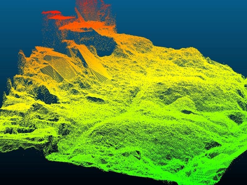
LiDAR Point Cloud
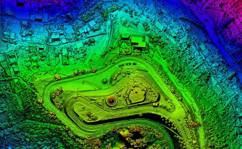
LiDAR (Light Detection and Ranging) is a remote sensing technology that uses laser pulses to measure distances to the surveyed area. LiDAR drone technology can be used to create highly accurate 3D models of the terrain and features of the area. LiDAR data can be combined with aerial data to create a highly detailed point cloud that can be used for a range of applications, including land surveying, infrastructure inspection, and environmental monitoring.
Thermal Maps
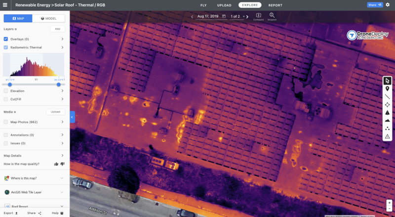
Drone surveying can also be used to capture thermal images of the surveyed area. Thermal images can be used to identify areas of heat loss or gain, which can be useful for building inspections and energy audits. Thermal images can also be used to identify areas of vegetation stress or water loss, which can be useful for environmental monitoring.
Multispectral Map
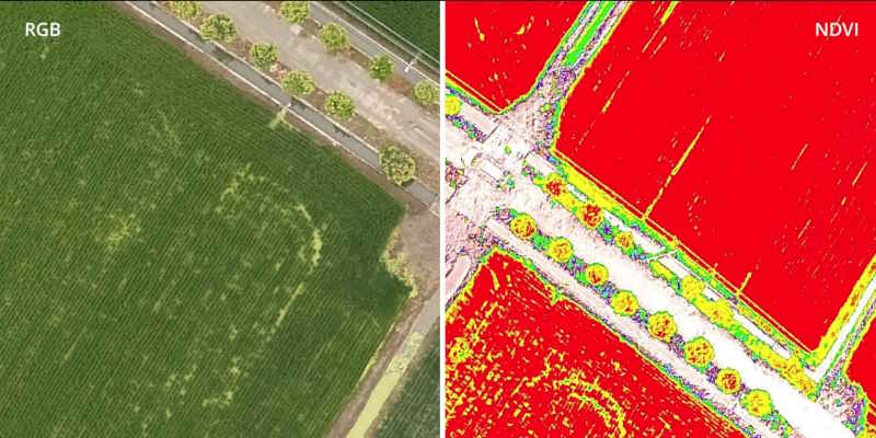
Multispectral imaging is a technique that captures images in multiple wavelengths, allowing for the identification of specific features or materials. Multispectral imaging can be used to create maps of vegetation health, soil moisture, and other environmental factors. These maps can be used for a range of applications, including precision agriculture, environmental monitoring, and land management.
Difference Between Photogrammetry and Lidar
Lidar and photogrammetry are two commonly used technologies for aerial surveying and mapping. Both technologies are used to collect data about the surface of the earth, but they use different methods to do so. Lidar can be used to map areas with complex terrain, while photogrammetry can be used to cover larger areas.
Lidar
Lidar, which stands for Light Detection and Ranging, uses laser pulses to measure the distance between the sensor and the ground. The laser pulses are emitted from the sensor and bounce back to the sensor after hitting the ground. By measuring the time it takes for the laser pulse to bounce back, the sensor can determine the distance between the ground and the sensor.
Lidar can produce high-resolution 3D point clouds of the earth’s surface, which can be used to create accurate maps and models. Lidar is particularly useful for mapping areas with complex terrain, such as mountains and forests.
Photogrammetry
Photogrammetry, on the other hand, uses photographs to create 3D models of the earth’s surface. Aerial photographs are taken from different angles and are used to create a 3D model of the terrain. Photogrammetry software is used to stitch the photographs together and create a 3D model.
Photogrammetry is less expensive than Lidar and can be used to cover larger areas. However, it is less accurate than Lidar and is not suitable for mapping areas with complex terrain. The choice of technology depends on the specific requirements of the project.
Drone Surveying Equipment
Here is the overview of essential components and advanced technologies used in drone surveying:
- Drone: The drone used for surveying must have a high-resolution camera, long battery life, and stability in windy conditions. Popular drones used for surveying include the DJI Phantom 4 RTK, DJI Matrice 300, and DJI Mavic 3 Enterprise.
- Fixed-wing Drone: A fixed-wing drone is ideal for large-scale mapping projects as it can cover more ground and fly longer distances. The Sensefly eBee and eBee X are popular fixed-wing drones used for surveying.
- RTK Technology: RTK technology is used to provide accurate positioning data for the drone. The DJI Phantom 4 RTK and DJI Matrice 300 both have built-in RTK technology.
- GS RTK App: The GS RTK app is used to plan flight paths, set waypoints, and monitor the drone’s progress during flight.
Advanced Drone Land Surveying Technologies
The following are advanced technologies used in drone surveying:
- GIS: Integral to spatial analysis, photointerpretation, and database management. GIS facilitates the generation of change detection assessments and thematic databases, aiding in the mapping of diverse elements such as natural features (e.g., forests, trees, landslides) and anthropic structures (e.g., buildings). Furthermore, GIS empowers accurate distance measurement within geospatial contexts.
- Photogrammetry: processes data acquired from drone surveys using advanced algorithms to generate orthophotoplans, 3D models, and various products. These outputs contribute to the creation of high-resolution, highly accurate land assessments, providing valuable insights for a range of applications.
- LiDAR: Light Detection and Ranging (LiDAR) technology is used to create highly accurate 3D maps of the surveyed area. LiDAR uses laser pulses to measure distances and create a detailed point cloud of the terrain.
- Multispectral Imaging: Multispectral imaging is used to capture data beyond the visible spectrum, such as infrared and ultraviolet light. This data can be used to identify and analyze vegetation health and other environmental factors.
- Deep learning and machine learning: Using AI techniques – DL and ML is used to analyze data collected by the drone and provide insights into the surveyed area. This technology can be used to identify and classify objects, extract objects, create change d
- Thermal Camera – A thermal camera is an apparatus designed to detect heat radiation, making it particularly valuable for identifying temperature variances in objects and environments. This technology finds crucial application in areas like search and rescue operations and infrastructure inspections, where the ability to detect heat anomalies is paramount for safety and assessment purposes.
- Cloud-Based Data Storage and Analysis – A system for securely storing and analyzing data in remote servers accessible via the internet, offering scalability and collaboration benefits for drone surveying projects.
- Autonomus Flight Planning – The automated process of predefining flight routes, waypoints, and survey parameters for drones, enhancing efficiency and accuracy in data collection during aerial missions.
Steps in Drone Surveying and Mapping
Here are the essential steps to follow when conducting a drone survey and mapping.
Flight Planning
The first step is to plan the survey flight. This involves selecting the area to be surveyed, determining the flight time required, and selecting the appropriate flight modes for data collection. The flight plan should also include the location of ground control points (GCPs) to ensure accurate data collection.
Most of the time, flight planning begins with the selection of the area of interest on which the flight will be made, the setting of the flight parameters such as the speed of the drone, the flight height of the drone, the overlap for taking images (in the case of photogrammetry projects), the speed wind, camera angle, terrain configuration (requiring a better digital terrain model than the one in the planning software if the flight is at low altitudes over very rugged terrain). The above parameters will directly affect the flight time required to perform the survey.
Ground Control
Ground control is an essential aspect of drone surveying and mapping. It involves placing GCPs in strategic locations to ensure accurate data collection. The GCPs are used to calibrate the drone’s GPS and camera to ensure accurate data collection. The base station is also set up to receive data from the drone during flight. If RTK technology is used, the use of GCP will not be necessary.
Data Acquisition
Once the flight plan and ground control are in place, the drone can be flown to collect data.
The quality of the data can be directly affected by the type of camera and its resolution for taking the image, by the weather conditions (the wind can stimulate the vegetation that will appear erased on the images), as well as by the altitude of the flight.
Data Processing
After data collection, the data is processed using software such as Agisoft Metashape and Pix4D or DJI Terra. The data is used to create maps and models that can be used for various purposes such as monitoring crop health, tracking construction progress, and identifying mineral deposits.
In conclusion, drone surveying and mapping is a highly efficient method for collecting data for various industries. Following the essential steps outlined above will ensure accurate data collection and high-quality data processing.
FAQ
Drone Surveying for Land Surveyors
Using drones for surveying lifts alot of weight for traditional land surveyors as we demonstrated above. The data collected by drones can be combined with data collected using traditional methods to to achieve even better results. With enhanced visualization and analysis capabilities, drone surveying is helping land surveyors make better decisions and models.
To recap models can be used in the restoration of heritage, historical buildings, where with the help of 3D models, problems in the structure can be identified, degraded buildings can be identified or even the volumetric calculation of the necessary expenses for repairs.
Will Drones Replace Surveyors
While drones can certainly make surveying and mapping more efficient and cost-effective, they are not likely to replace surveyors entirely. Surveyors bring a level of expertise and experience that cannot be replaced by technology alone.
At this moment, autonomous drones, which pilot themselves with the help of a well-structured flight plan, are in continuous development. The disadvantage of these drones is the huge cost that is needed for the development of the technology, but which will decrease from year to year.
It’s also worth noting that drones have limitations. They may not be able to access certain areas or provide the level of detail required for certain types of surveys. In these cases, surveyors will still need to rely on traditional methods.
Access to military areas, the proximity of airports or international areas, congested areas, as well as flying at a high altitude, may be restricted for safety reasons. While drones can be a useful tool for surveying and mapping, they are not likely to replace surveyors entirely. Surveyors will still play an important role in ensuring accurate and reliable data.
How Much Does a Survey Drone Cost?
The cost of a survey drone can vary greatly depending on the make, model, and features. Generally, a basic drone for surveying can cost anywhere from $1,000 to $5,000. However, if you need a more advanced drone with higher accuracy and more features, the cost can range from $10,000 to $50,000 or more.
It’s important to note that the cost of the drone is not the only expense. You’ll also need to factor in the cost of software, licensing, training, and maintenance. Additionally, if you plan to hire a professional drone operator, their fees will also need to be considered.
Regulatory and Legal Considerations
Drone surveying and mapping are subject to various legal and regulatory considerations that must be taken into account before conducting any operations. Failure to comply with these regulations may result in penalties, fines, and legal consequences. This section provides an overview of the regulatory and legal considerations that drone operators must be aware of when conducting surveying and mapping operations.
Legal Considerations
Drone operators must comply with all applicable federal, state, and local laws when conducting surveying and mapping operations. These laws may include privacy laws, trespass laws, and nuisance laws. Drone operators must also obtain permission from property owners before conducting operations over their property.
FAA Regulations
The Federal Aviation Administration (FAA) regulates drone operations in the United States. Drone operators must comply with all FAA regulations, including Part 107 regulations. Part 107 regulations apply to commercial drone operations and require drone operators to obtain a remote pilot certificate and follow specific operational requirements.
Part 107 Regulations
Part 107 regulations require drone operators to follow specific operational requirements when conducting commercial drone operations. These requirements include the following:
- Drones must weigh less than 55 pounds.
- Drones must be flown below 400 feet above ground level.
- Drones must be flown within visual line of sight of the operator.
- Drones must not be flown over people or moving vehicles.
- Drones must not be flown from a moving vehicle.
LAANC Waiver
The Low Altitude Authorization and Notification Capability (LAANC) is a system that allows drone operators to obtain authorization to fly in controlled airspace. Drone operators must obtain a LAANC waiver before conducting operations in controlled airspace.
In conclusion, drone surveying and mapping operations are subject to various legal and regulatory considerations that must be taken into account before conducting any operations. Drone operators must comply with all applicable laws and regulations, including FAA Part 107 regulations and LAANC waivers, to avoid penalties and legal consequences.
- Drone Pipeline Inspections in Oil and Gas Industry - November 23, 2023
- Wind Turbine Inspection using Drones - November 16, 2023
- Agriculture Drone Mapping: Data-Driven Decisions - October 29, 2023