
Drones for Water Resource Management and Monitoring
Drones have been increasingly used in various industries to improve efficiency, accuracy, and safety. One of the sectors that have embraced this technology is the water utilities industry. Drones have proven to be useful in a wide range of applications, from monitoring water quality and quantity to inspecting infrastructure and detecting leaks.
One of the primary benefits of using drones in water utilities and water resource management is the ability to collect data quickly and accurately. Drones equipped with sensors and cameras can capture high-resolution images and videos of water sources, treatment plants, and distribution networks. This data can be used to identify potential issues, such as leaks, blockages, or contamination, and address them promptly. Moreover, drones can cover large areas in a short amount of time, reducing the need for manual inspections and saving resources.
Another advantage of using drones in water management is the enhanced safety they provide. Inspecting water infrastructure often involves working at heights, in confined spaces, or near hazardous chemicals.
Pipes and culverts often hinder workers’ movement, making it difficult to perform an effective inspection. These tasks can be dangerous and time-consuming, requiring specialized equipment and personnel. Drones can perform these inspections without putting workers at risk, providing a safer and more efficient alternative.
Drone Applications in Water and Hydrology Management
Drones are becoming increasingly popular in water management due to their ability to perform tasks that were previously time-consuming and expensive. In this section, we will discuss the various applications of drones in water and hydrology management.
Inspection
Drones can perform inspections of water utilities infrastructure, such as pipes and reservoirs. They can detect leaks, rust, and other damage that may be difficult to identify from the ground. This information can be used to make repairs and improve the overall efficiency of the water system.
Surveying
Drones can create 2D and 3D models of water utilities infrastructure. This can help water utilities managers to better understand the system and plan for future improvements. The spatial resolution of drone imagery can be very high, allowing for detailed documentation and drawings of water utilities infrastructure.
Water sampling using Drones
Drones can be used to collect water samples from remote locations. This is particularly useful for water utilities that have large service areas or that serve rural communities. By leveraging advanced technology, we can ensure the health and safety of both our water sources and the teams responsible for their management.
Asset Management
Drones can be used to monitor the condition of water utilities assets, such as pumps and valves. This information can be used to schedule maintenance and repairs, reducing downtime and improving the overall efficiency of the water system. Thermal imaging can also be used to detect heat signatures, which can indicate potential problems with assets.
Hydrological Processes Assessment
Unmanned aerial vehicles are capable of delivering valuable insights into hydrological processes, including runoff, infiltration, and evapotranspiration. This data can be leveraged to create predictive models for future water availability and to evaluate the effects of climate change on our water resources.
Drone Based Asset Inspection for Water Utilities
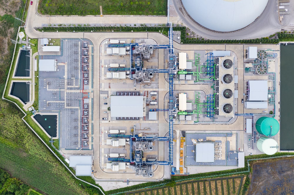
Drone technology provides numerous benefits in the way water utilities conduct asset inspections. With the ability to capture high-resolution images and video, drones can provide a comprehensive view of water utility assets, including pipelines, water towers, reservoirs, aqueducts, access/ventilation shafts, sewer systems, cable/communication tunnels, and enabling public water supply surveillance and monitoring more efficently.
Pipeline Surveys and Inspections
Drones equipped with high-resolution cameras and thermal imaging sensors can inspect pipelines for leaks, corrosion, and other damage. By detecting these issues early, water utilities can avoid costly repairs and reduce the risk of service disruptions.
Water Tower Inspections
Water towers, or Water Tanks, are critical components of water distribution systems. Drones can inspect water towers for structural damage, corrosion, and other issues that could compromise their integrity. By using drones for water tower inspections, water utilities can reduce the risk of catastrophic failures and ensure the safety of their employees and the public.
Wastewater Treatment Facilities Inspection
Regular inspections of wastewater treatment plants are necessary to ensure that best practices are being followed. Drones provide a unique solution to this challenge, offering a bird’s eye view of the entire system and allowing for easy detection of abnormalities. Not only do drones cut down on costs, but they also save time as traditional inspection methods can take weeks to complete. With drones, data can be collected on site within minutes, enabling managers to spot potential problems before they occur. Drones can even be deployed in dangerous places such as collector and pumping station interiors.
Inspecting Water Reservoirs
Water reservoirs are essential for storing and distributing water. Drones can inspect reservoirs for cracks, leaks, and other damage that could affect their structural integrity. By using drones for reservoir inspections, water utilities can identify issues early and take corrective action before they become more significant problems.
Aqueducts
Drones can inspect aqueducts for damage, erosion, and other issues that could affect their ability to transport water. By using drones for aqueduct inspections, water utilities can identify areas that need repair or maintenance and take action before they become more significant problems.
Access / Ventilation Shafts
Access and ventilation shafts are critical components of water utility infrastructure. Drones can inspect these areas for damage, blockages, and other issues that could affect their function. By using drones for access and ventilation shaft inspections, water utilities can ensure the safety and reliability of their infrastructure.
Sewer Inspection
Drones can inspect sewer systems for blockages, leaks, and other issues that could affect their function. By using drones for sewer inspections, water utilities can identify issues early and take corrective action before they become more significant problems.
Cable / Communication Tunnels
Cable and communication tunnels are essential for transmitting data and communications. Drones can inspect these tunnels for damage, blockages, and other issues that could affect their function. By using drones for cable and communication tunnel inspections, water utilities can ensure the reliability of their infrastructure.
Enclosed Culverts
Enclosed culverts are critical components of water utility infrastructure. Drones can inspect these areas for damage, blockages, and other issues that could affect their function. By using drones for enclosed culvert inspections, water utilities can ensure the safety and reliability of their infrastructure.
Tracking the progress of ongoing projects
Drones are equipped with high-resolution cameras, which can capture images of the construction site from various angles. These images can be used to create 3D models of the site, which can be used to monitor site progress, identify any potential issues, and ensure that our teams are working efficiently and effectively.
Water Distribution System Leakage Detection
Water distribution systems are essential for providing clean water to households and industries. Leakage in these systems can cause significant damage to infrastructure and the environment. Using UAV for water leakage detection offers a more efficient and accurate approach compared to traditional methods. In this section, we will discuss several techniques employed by drones to detect leakages in water distribution systems.
Visual Inspections
Visual inspections are the most common method of detecting leaks throughout water pipeline system. It involves trained personnel visually inspecting pipelines, valves, and other components of the system for signs of damage or leaks. Drones equipped with high-resolution cameras can provide real-time aerial imagery for visual inspections of water pipeline networks. This allows to quickly identify signs of leakage or any structural damage, such as cracks, corrosion, or misalignments. Moreover, drone imagery provides:
- Monitor hard-to-reach areas without endangering personnel
- Reduce site inspection times
- Detect leaks at an early stage, minimizing water loss
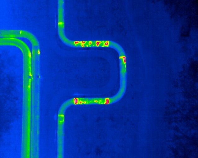
Thermal Imaging
Thermal imaging technology uses infrared cameras to detect temperature differences on the surfaces of water pipes. When drones with thermal imaging capabilities are flown over the water distribution system:
- Warm areas may indicate water leakage, as escaping water will have a different temperature compared to the surrounding soil
- The contrast in temperature readings can help us determine the location and extent of leaks before they worsen
Lidar Technology
Lidar (Light Detection and Ranging) technology uses laser-based remote sensing to create detailed 3D maps of a water distribution system. By implementing drones with Lidar, we can:
- Obtain precise measurements of pipelines and their surroundings
- Identify small changes in elevation or ground deformations that may indicate leakage
- Capture data at a higher point density, providing a more accurate representation of the pipeline network
Multispectral Imaging
Multispectral imaging involves capturing images at different wavelengths to analyze various elements of a scene (e.g., vegetation, soil, and water). Drones equipped with multispectral sensors can help us detect water leakages through the following:
- Analysis of vegetation: Increased moisture content in the soil can result in greener vegetation, signaling a possible leak
- Moisture detection: Water leaks can alter the moisture content of soil, which can be detected through multispectral imaging
- Change detection over time: By comparing multispectral data over regular intervals, we can identify potential leaks and monitor the progression of existing ones
By leveraging these advanced drone technologies, we efficiently and accurately detect, monitor, and address water distribution system leakages, ultimately conserving valuable water resources and minimizing damage to infrastructure.
Hydrological Monitoring
River and Lake Monitoring and Supervision
Monitoring Rivers and Lakes on consistent and methodical level was always time consuming and expensive. Using Drones as part of the process on supervision and monitoring water resources significantly reduces operational costs. Providing effective and efficient tool for natural resource inspection, allowing us to gather crucial information while minimizing environmental impact.
Drones equipped with advanced sensors can collect data on water quality parameters like pH, temperature, turbidity, and oxygen levels. We can monitor the growth of aquatic plants, detect erosion in riverbanks, and assess the impact of human activities on the water and wildlife. This valuable information can help to identify any changes or potential threats to the ecosystem and take appropriate action.
Some of the key benefits of using drones for these tasks include:
- Time and cost savings: Traditional techniques such as boat-based surveys and manual data collection can be time-consuming and labor-intensive. Drones enable us to operate quickly and efficiently, reducing the overall costs.
- High-resolution imagery: Drones can capture high-quality images and videos, enabling us to conduct a detailed assessment of rivers and lakes without putting our team members at risk or disturbing the environment.
- Access to hard-to-reach areas: Drones make it easier to inspect remote and inaccessible water bodies, ensuring we have comprehensive and up-to-date information about their condition.
- Real-time data: With drone technology, we can access the collected data in real time, allowing us to make informed decisions and take prompt action if needed.
By using drones for river and lake monitoring and supervision, we can optimize our resources and maintain the highest standards in water and utilities management.
Mapping Water Bodies and Estimating Water Coverage
In order to estimate water coverage, we utilize specialized software that processes the captured imagery and data to generate accurate measurements of water volumes and surface areas. This information is invaluable in managing water resources and anticipating potential issues, such as flooding or drought.
Some key applications of our drone-based water mapping and estimation services include:
- Monitoring water levels in reservoirs and lakes to optimize water distribution
- Assessing river flow rates and changes in water levels to inform flood management planning
- Evaluating water quality and identifying pollution hotspots for targeted intervention
- Mapping wetlands and other environmentally sensitive areas to support ecological studies and conservation efforts
By leveraging drone technology in our water mapping and estimation services, we can provide valuable insights that enable better decision-making and resource management for water and utility organizations.
Supporting flood risk assessment and emergency management
With drone applications, water utilities can quickly assess the extent of flood damage, identify areas that are at risk of flooding, and monitor water levels in real-time. This information can help water utilities to make informed decisions about deploying resources and personnel to areas that need the most help.
Drones equipped with high-resolution cameras can capture detailed images of flood-affected areas, which can be used to create maps and 3D models of the flood zone. These maps and models can help water utilities to identify areas that are at risk of flooding and prioritize their response efforts accordingly.
Industrial Outfall Monitoring
Industrial outfall such as the discharge of wastewater or effluents from industrial facilities into natural water bodies, such as rivers, lakes or oceans. Industrial outfall can have negative impacts on the environment and human health, such as water pollution, habitat degradation, and disease transmission.
Drones can offer several advantages for industrial outfall monitoring, such as:
- They can collect high-resolution images and videos of the outfall sites and surrounding areas, which can help identify the sources, locations, and extent of the discharge.
- They can carry sensors and cameras that can measure various parameters of the wastewater, such as temperature, pH, dissolved oxygen, turbidity, and chemical composition.
- They can reduce the cost and time of data collection, as they can cover large areas quickly and efficiently, without the need for human operators or boats.
- They can improve the safety and security of data collection, as they can avoid hazardous or inaccessible areas, such as rough waters, high cliffs, or restricted zones.
Soil and Water Conservation Investigation
Drones can help identify areas of erosion, soil degradation, and water pollution. They can also provide valuable information on soil moisture levels, which can help to optimize irrigation practices and reduce water waste.
Drones can also be used to monitor the health of riparian zones, which are critical for protecting water quality. Riparian zones are areas of land that border streams, rivers, and other bodies of water. They help to filter pollutants and sediment from runoff before it enters the waterway. Drones can provide valuable information on the health of riparian zones, including vegetation cover, soil moisture levels, and erosion.
Case Studies
Anglian Water from England utilizes drones to find and fix hidden leaks during drought. Water companies in France have taken to the skies, using drones to inspect their sewer operations. In New Zealand, drones are being employed as part of a project to monitor water quality. In Ireland, drones are being used to survey potential problems and catch illegal dumping before it becomes an issue for wastewater treatment workers. The use of drones in the wastewater industry has proven to be a game-changer, increasing worker safety, reducing energy consumption, streamlining planning, improving insight and education, and efficiently collecting samples.
- Drone Pipeline Inspections in Oil and Gas Industry - November 23, 2023
- Wind Turbine Inspection using Drones - November 16, 2023
- Agriculture Drone Mapping: Data-Driven Decisions - October 29, 2023